Cishan river flows through severe disaster areas such as Namasia, Jiaxian, Shankin and Cishan. Among them, Shiaolin village, Jiaxian was buried by landslide caused by Typhoon Morakot and hundreds of people were killed. It took more than one year to rebuild the destroyed bridges across Cishan river. The road that leads to Shiaolin village and Namasia from Jiaxian was damaged so the rescue efforts had to be based on the helicopter headquarters established in Cishan junior high school downstream Cishan river. Many large landslides have appeared upstream the river and one of them even formed a large landslide dam which is visible on satellite imagery taken after one month.
2009 Honduras Earthquake
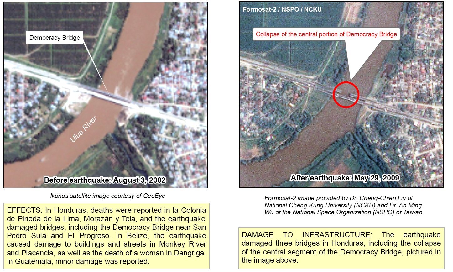
(28 May 2009)
The earthquake occurred in the Caribbean Sea at 2AM local time on May 28, 2009. It stuck Central America, but also showed the rapid response of our team. Formosat-2 had been scheduled to take imagery of Central America 3 hours after the earthquake happened. 5 hours after it’s been scheduled, Formosat-2 passed Belize and imagery was downloaded to NSPO and processed by our team. The analyzed results were provided to the UN organization, GEOSS, in support of the disaster relief of Central America. The rapid response process has hit the world record that satellite imagery could be collected right after the disaster. It also hit the headlines of Science@NASA
2009 Queensland Floods
(February 2009)
Subordinated to GEO, GEOSS has noticed Formosat-2’s daily revisit ability and our rapid response results of global natural disaster. As Australia was hit by severe floods and bushfires on February 2009, we were invited to investigate these disasters by applying EO-1, RadarSat-2, Landsat and Formosat-2 and offer precious data for further disaster relief and assessment.
The Black Saturday Bushfires
(February 2009)
A week before the fires, an exceptional heatwave affected southeastern Australia. The heatwave was caused by a slow moving high-pressure system that settled over the Tasman Sea with a combination of an intense tropical low located off the North West Australian coast and a monsoon trough over northern Australia, which produced ideal conditions for hot tropical air to be directed down over southeastern Australia . The extreme weather condition triggered the Black Saturday Bushfires. We employed RSI carried by Formosat-2 and ALI carried by NASA’s Eo-1 satellite and analyzed their high spatiotemporal and multispectral imagery. The results indicated that Formosat-2 imagery has the privilege to identify where the bushfires ignited and the range of burning and destroyed areas. It also provided a great example of creating the SensorWeb to monitor global disasters.
2009 Angola, Namibia and Zambia Floods
(March 2009)
Floods occur in Namibia during the rainy season almost every year, and our rapid response team has applied Formosat-2 satellite imagery in support of the international disaster relieving action. Within 3 months’ cooperation, we analyzed more than 71 images which reveal a big lake had been formed in the area around Lake Liambezi after the rainy reason.
2008 Sichuan Earthquake
(12 May 2008)
As Sichuan Earthquake happened on 12 May 2008, severe casualties and damages have been reported and the traffic of many disaster areas has been cut off. Many countries had offered rescue teams, and satellites were scheduled to capture the latest imagery of disaster areas. Cooperated closely with NSPO, we initiated the variance analysis of severely struck Beichuan County and Wenchuan County in the afternoon of 14 May. Compared with imagery taken two years ago, landslides, landslide dams, collapsed bridge, broken roads and destroyed houses were clearly identified. Confirmed by photos posted on website by local residents and reporters, Formosat-2 imagery indeed indicated the real condition after this earthquake. We also provided NASA’s natural disaster website these imagery.
Wilkins Ice Shelf Collapse
(28 February 2008)
Wilkin Ice Shelf is located on the southwest side of the Antarctic Peninsula and 1600 kilometers away from the south pole of South America. A series of collapse events started on 28 February 2008 signified the dramatic change of global climate has caused severe consequence in the Antarctic area. Worked with NSPO, we captured imagery in where Wilkin Ice Shelf collapsed by employing Formosat-2’s unique orbit and advanced imagery processing technique. The 2-meter resolution imagery captured on 8 March revealed the detailed process of how the ice shelf disintegrated. Collecting and integrating all kinds of data, we published a report on the investigation of this event along with NSIDC and BAS. For more details, please see this article.
The October 2007 California wildfires were a series of wildfires that began burning across Southern California on October 20. Major contributing factors to the extreme fire conditions were drought in Southern California, hot weather, and the strong Santa Ana winds. At least 1,500 homes were destroyed, over 500,000 acres of land burned, 14 people were killed and 70 people were injured. We set up the range of Formosat-2 imagery by employed 1-meter resolution imagery taken by NASA’s MODIS satellite and used our F-2 AIPS system to interpret the burning condition of Poomacha area. On the 2-meter resolution Formosat-2 SSIM false color imagery, the location of flame and fire can be marked precisely even though the range was just a few meters wide. Please see this article for more information. Liu, C.-C.*, Wu, A.-M., Yen, S.-Y. and Huang, C.-H. (2009) Rapid locating of fire points from Formosat-2 high-spatial-resolution imagery: example of the 2007 California wildfire. International Journal of Wildland Fire. 18(4), pp. 415 - 422
Hurricane Katrina
(August 2005)
Landed from the Gulf of Mexico, Hurricane Katrina was a powerful Atlantic hurricane that struck Louisiana, Mississippi and Alabama and caused the most serious disaster in the last 100 year of America’s history since the 1906 San Francisco earthquake. More than 1,000 people died and 1,000,000 people were evacuated from their homes. Since the levee system catastrophically failed, 80% of New Orleans became flooded. Formosat-2 satellite imagery has been collected for one month, and the comparison of these two images clearly reveals locations of one fire and three levee failures. In addition, the range of flood in residential areas can be identified on the 2-meter resolution Formosat-2 SSIM imagery.